Project Description

The capability of Sentinel-5p for aerosol monitoring is currently not used to its full potential. However, satellite observations in the spectral range from approximately 340 to 400 nm are known to have unique sensitivity to elevation and absorption of tropospheric aerosols. Traditionally, this sensitivity is used in many ozone monitoring instruments such as TOMS, GOME-1, SCIAMACHY, OMI and GOME-2 for deriving UV Aerosol Index (UVAI) that provides very valuable qualitative information about aerosol distribution. However, UVAI does not have explicit geophysical quantitative meaning and, therefore, it is not fully appropriate for utilization in validation of aerosol transport models and other climate applications.

The reflectivity of the Earth’s surface is an important input parameter for many satellite retrievals of atmospheric composition. Examples are the retrieval of trace gases such as ozone, NO2, BrO, CH2O, H2O, CO2, CO, and CH4, and of cloud information and aerosol optical depth (AOD). Recent developments in atmospheric remote sensing have focused strongly on deriving and implementing angular-dependent surface BRDF information (as opposed to using traditional, non-directional Lambertian surface reflectivity information), and on obtaining this information on a much higher spatial resolution than before.

ESA S5P+I AOD/BRDF project is focused on aerosol and surface reflectance characterisation using capabilities of Sentinel-5p (TROPOMI) measurements.

One objective of the project is to achieve quantitative characterization of aerosol properties from Sentinel-5p. Specifically, the objective is to develop the algorithm capable to provide Aerosol Optical Depth (AOD), i.e. aerosol load in the atmosphere as well as to provide information about absorption and type of the aerosol.

Another objective of the RFP/ITT is the development of a product of spectral surface BRDF information from (and for) the TROPOMI instrument.

Proposed Approach

The ultimate aim of the project is to have an integrated retrieval algorithm for making AOD and BRDF products from TROPOMI using the GRASP approach. In addition to the integrated algorithm products, there will also be intermediate products of AOD and BRDF based on the OMI-heritage algorithms.

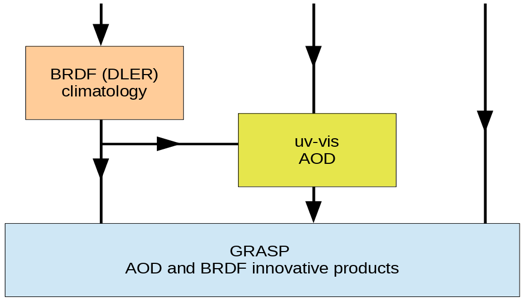
The integration approach proposed in this work is schematically here:


One key element of the approach employed in this project is utilization of Generalized Retrieval of Aerosol and Surface Properties (GRASP) as a state-of-the-art retrieval strategy for generating enhanced aerosol and BRDF products from Sentinel-5p. GRASP is a recently developed (Dubovik et al. 2011, 2014) open source (https://www.grasp-open.com) versatile algorithm that provides simultaneous retrieval of both aerosol and surface properties from diverse satellite and ground-based passive and active observations. GRASP retrieval is implemented as highly advanced statistically optimized fitting of all available observations.

In addition, GRASP uses an innovative multi-pixel concept in which the fitting is realized simultaneously for large group of “pixels” (coordinated observations). This principle is especially useful for improving satellite retrievals where it allows benefitting from known a priori limitations on space and time variability of different surface and aerosol parameters. This helps reliable discrimination between aerosol and surface contributions in observation that is generally known as a challenging issue. Application of such a multi-pixel strategy is particularly important for improving retrieval from single-view satellite observations as those from Sentinel-5p, because the concept ensures uniqueness of the solution even if the number of unknowns for each individual pixel is quite high. In addition, GRASP is based on positive retrieval heritage. Specifically, the approach has originated from the AERONET retrieval and was improved and extended for the interpretation of satellite and airborne observations, both by passive and active sensors. Therefore, the concept and the software have been polished in diverse applications. For example, GRASP was applied for processing observations from multiple satellite sensors such as POLDER/Parasol, MERIS/Envisat, MISR/Terra, and is being selected as operational algorithm for future missions such as 3MI/Metop, Sentinel-4. Furthermore, the GRASP concept is highly suitable for synergy retrieval. At present, it is employed for processing combined observations from ground-based radiometers and lidars in the European ACTRIS network.

It should be noted that GRASP, as follows from the name of the approach, is aimed on simultaneous retrieval of aerosol and surface. As described in the formulation of the algorithm, such a strategy results in the retrieval of fully radiatively consistent aerosol and BRDF parameters of higher accuracy compared to the conventional approaches, in which surface and aerosol properties are derived separately. Additionally, GRASP is a very flexible algorithm built on rather general principles and can be easily changed and adjusted if any potential improvement is identified.

Another key element of the approach employed in this project is the consideration of all positive previous experiences in development and exploitation of aerosol and surface retrievals from TOMS, GOME(-2), SCIAMACHY and OMI UV sensors. This includes the benefit from rather specific knowledge regarding particular features important for the development of an adequate forward Radiative Transfer (RT) model, regarding uncertainties and potential issues typical for UV spectrometers, known data sensitivities of the observations, general strength and weaknesses of used developed approaches, etc. For example, conventional OMI-like algorithms implemented pre-calculated Look-Up-Tables (LUT), therefore such algorithms are much faster than GRASP, which implements all RT calculations online during the retrieval. Therefore, results of such algorithms can be used for optimizing GRASP initialization or express checking of some retrieval assumptions. Finally, having a possibility of comparing results of algorithms using fundamentally different concepts is always highly beneficial to assure robust progress in the retrieval development.

The consortium of the project includes the core teams of specialists closely involved in the original development and exploitations of both GRASP and OMI algorithms that assures the best composition of the project team for successful realization of the project following above described development approach.

Project Consortium


GRASP EARTH shorten from ‘Generalized Retrieval of Atmosphere and Surface Properties” is a company that was founded in February 2015 with the main goal of development of remote sensing algorithms and scientific methods for environment studies of atmosphere and surface of the Earth. The initial idea of GRASP has been developed by the efforts of CNRS and University of Lille. Then this base scientific concept has been realized in open-source GRASP-OPEN software adapted to diverse remote sensing applications. The main GRASP SAS activities cover a wide range of remote sensing topics: –       Developments of algorithms for advanced atmosphere and surface characterization from passive and active ground based and space-borne remote sensing. –       Scientific consulting in environmental studies. –       Distribution and support of GRASP open source code. Since its creation, GRASP SAS has been involved in collaboration with world-wide environmental public organizations and private companies, universities and the largest space agencies (ESA, EUMETSAT, NASA, JAXA) with the goal to improve the scientific knowledge of the atmosphere and surface properties, which have an essential impact on Earth climate, and tightly interconnected with human activities. The GRASP code was developed for advanced aerosol and surface retrieval from remote sensing measurements. GRASP SAS is composed by a unique team with full understanding all aspects of the code: physical and mathematical basis, software optimization etc. GRASP team has leaded several projects to retrieve atmosphere and surface parameters from different satellite sensors (PARASOL, MERIS, Sentinel 3 and 4, 3MI).

Cloudflight Austria GmbH was founded as Catalysts GmbH in 2007 and has grown to over 400 employees distributed over offices in Austria, Germany, Romania and The Netherlands. We develop individual software solutions for industry, agencies, and the public sector focusing on Big Data and Machine Learning (batch processing of Tera- and Petabytes, process of data streams in real time or near real time), High Performance Computing (acceleration of algorithms), and Large-Scale Agile Projects (large-scale agile software projects „On Time & On Budget“). Cloudflight’s large international customer base includes Porsche/Volkswagen, Fraport, DB, Raiffeisen, EUMETSAT, and the European Space Agency. Our customers value our solid problem-solving competence so that they can grow further. Cooperation exists with several national and international universities, including the Technical Universities of Vienna and Graz, the LOA at the University of Lille, the Free University of Berlin, the Kindai University in Osaka, the Austrian Met-Office ZAMG, the Austrian Environmental Agency Umweltbundesamt, the German DLR, and NASA. As part of the consortium carrying out the “Sentinel-4 Level 2 Processor Component Development” project for ESA, Cloudflight is providing the prototype and operational processors for surface and aerosol optical depth for the Sentinel-4 mission using the GRASP algorithm. The processors will be integrated in EUMETSAT’s MTG Level 2 Processing Facility. In the frame of the ESA CAWA project, “Advanced clouds, aerosols and water vapor products for Sentinel-3” the MERIS/Envisat full mission and 6 months of OLCI/S3A were reprocessed using GRASP as precursor for improved Sentinel-3 L2 products. In the frame of the EUMETSAT study “Study on Optimization of the GRASP Algorithm for the 3MI L2 Aerosol Retrieval”, Cloudflight and GRASP SAS are preparing the integration of the GRASP algorithm into the EPS-SG ground segment as operational Level 2 processor for Aerosol and Surface Reflectance for the Multi-viewing Multi-channel Multi-polarization Imaging instrument, 3MI. 3MI can be considered an operational successor of the PARASOL mission, and will provide the best basis for future aerosol characterization from satellites. In the frame of the “GRASP Cloud project” tasked by the Beyond Europe Initiative of the Austrian Federal Ministry of Science, Research, and Economy, BMWFW, Cloudflight is developing a cloud service for data processing using the GRASP algorithm, together with GRASP SAS (France), EODC (Austria), NASA (JPL and GSFC, USA), Airphotons (USA), Kindai University (Japan), and RADI (China). The service offered by the GRASP Cloud is the processing of Satellite, Ground-Station, and in-situ observations for public agencies and private enterprises.

The Royal Netherlands Meteorological Institute (KNMI) was established in 1854. It is a government agency operating under the responsibility of the Ministry of Infrastructure and Water Management. It is an operational institute that provides weather observations, weather forecasts, and vital weather information and warnings 24/7 all year round. The institute carries out applied and fundamental research in support of its operational tasks and as a climate change research centre. The R&D departments are covering the areas of Weather and Climate modelling, Seismology and Acoustics, Ground-based Observations and Data Technology, and Satellite Observations. It employs approximately 370 FTE staff. As an operational meteorological data centre and research institute in one, KNMI combines international relations and co-operation projects in a practical sense. KNMI is an active member of the World Meteorological Organisation, the European Centre for Medium-range Weather Forecasts and the European Organisation for the Exploitation of Meteorological Satellites. Satellite observations are of great importance to KNMI. For weather forecasting and for research and development activities, satellite observations provide a valuable complement to in-situ measurements. These data are applied in the first place for KNMI’s own operational and research tasks but KNMI also provides satellite observation products and related services as an aid to the exertion of public tasks. Furthermore, data and value added products are provided for national and international environment and climate change programmes. KNMI is involved in national and international studies concerning user aspects of satellite observation data. KNMI aims at establishing and extending the European infrastructure of ESA, EUMETSAT and EU satellite programmes.

Relevant to this proposal is KNMI’s R&D Satellite Observations department. In this department the themes are: Atmospheric Dynamics, using wind scatterometer missions and the Aeolus wind lidar; Clouds, aerosols, and solar radiation using Meteosat/SEVIRI, NOAA/AVHRR, and preparing for Earth-CARE; and Atmospheric Composition, using the UV-visible-near-infrared spectrometers GOME, SCIAMACHY, GOME-2, OMI, and TROPOMI. The department holds the Principal Investigator role for OMI and TROPOMI. It has leading expertise on pre-flight and in-flight calibration, and on retrieval of trace gases, clouds, and aerosols. Activities include the monitoring of air quality, especially NO2 and absorbing aerosols; ozone layer monitoring; cloud correction of trace gas retrievals; validation using ground-based and balloon-borne observations (O3, NO2); processing and delivery of operational satellite data products to users (e.g. TEMIS); and top-down estimates of emissions. In the Satellite Observations department also the work on the EUMETSAT Satellite Application Facilities on Atmospheric Composition, Climate Monitoring, and Ocean and Sea Ice is being performed. This includes the retrieval of ozone profiles, aerosols, surface albedo, and sun-induced fluorescence from GOME-2. The satellite products from OMI and TROPOMI include L1 data, ozone profiles, NO2 columns, clouds, aerosols, and surface albedo. In European collaboration, algorithms are currently being developed for Sentinel-4 and Sentinel-5.

Publications

De Graaf, M., et al., “How big is an OMI pixel?”, Atmos. Meas. Tech., 9, 3607-3618, Special Issue: Ten years of Ozone Monitoring Instrument, doi:10.5194/amt-9-1-2016, 2016.

Dubovik, O., et al., “Statistically optimized inversion algorithm for enhanced retrieval of aerosol properties from spectral multi-angle polarimetric satellite observations”, Atmos. Meas. Tech., 4, 975-1018, 2011.

Dubovik, O., et al. “GRASP: a versatile algorithm for characterizing the atmosphere”, SPIE: Newsroom, doi:10.1117/2.1201408.005558, Published Online: http://spie.org/x109993.xml, September 19, 2014.

Litvinov, P., et al. “Models for surface reflection of radiance and polarized radiance: Comparison with airborne multi-angle photopolarimetric measurements and implications for modeling top-of-atmosphere measurements”, Remote Sens. Environ., 115, 781–792, 2011.

Stammes, P., “Spectral radiance modelling in the UV-visible range”, in IRS 2000: Current Problems in Atmospheric Radiation, edited by W. L. Smith and Y. M. Timofeyev, pp. 385-388, A. Deepak, Hampton, Va., 2001.

Tilstra, L. G., et al., “Surface reflectivity climatologies from UV to NIR determined from Earth observations by GOME-2 and SCIAMACHY”, J. Geophys. Res. Atmos., 122, 4084–4111, doi:10.1002/2016JD025940, 2017.

Veefkind, J. P., et al., “Global satellite analysis of the relation between aerosols and short-lived trace gases”, Atmos. Chem. Phys., 11, 1255-1267, doi:10.5194/acp-11-1255-2011, 2011.

Veefkind, J. P., et al., “TROPOMI on the ESA Sentinel-5 Precursor: A GMES mission for global observations of the atmospheric composition for climate, air quality and ozone layer applications”, Remote Sens. Environ., 120, 70-83, doi:10.1016/j.rse.2011.09.027, 2015.

Data

The Data Pool is available under:
– https://download-portal.apps.openshift.grasp-cloud.com/download/s5p-datapool
– https://www.temis.nl/surface/albedo/tropomi_ler.php
– https://download.grasp-cloud.com/download/tropomi/

It currently (version 1) consists of:

– A representative dataset of AUX data and TROPOMI L1 and L2 data to run the algorithm.
Further L1 and L2 data are available for the project partners, being downloaded directly from S5p Copernicus datahub: https://s5phub.copernicus.eu

– Surface and aerosol databases:
 
1.Direct link to the DLER database:
 
3. GRASP TROPOMI aerosol database over 30 AERONET sites: 

4. GRASP TROPOMI surface BRDF/DHR/BHR_iso database (over 30 AERONET sites):  

5. Combined TROPOMI+AERONET GRASP surface BRDF/DHR/BHR_iso database (over 5 AERONET sites): 
 

6. GRASP/TROPOMI global aerosol and surface retrieval for 2019 and 2020:
https://download.grasp-cloud.com/download/tropomi/

The Data Pool allows for single file download via the web browser or tool-based download using the shown session password and Basic Authentication.

Access to the Data Pool is possible via GRASP Single Sign On.
If you don’t already have access and think you should have: please register for an account and contact the project team afterwards with your account details.